Andean orogeny — Southern Volcanic Zone arcEdifice built in four stages since the early Pleistocene (possibly late Pliocene); last confirmed eruption 560 CE ± 150 (subduction ongoing)Nazca plate subducting beneath the South American plate🌋 stratovolcano (dominantly effusive; summit dome, pyroclastic cones, tuff ring) — ACTIVE — SEGEMAR's Observatorio Argentino de Vigilancia Volcánica (OAVV) officially categorizes Lanín as an active volcano and ranks it 3rd in Argentina's volcanic risk ranking; monitored 24/7 by OAVV (seismometers, cameras) and by OVDAS-SERNAGEOMIN in Chile, which briefly raised the alert to Yellow after a February 2017 seismic swarm. Check the current alert level before climbing.
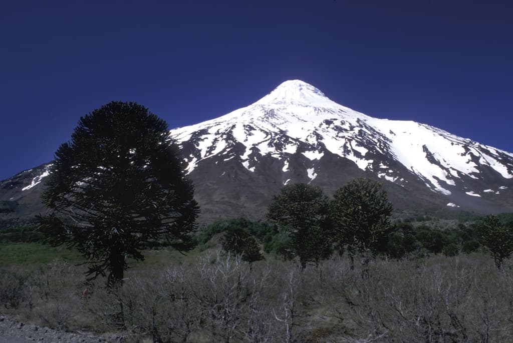
Lanín is a clean stratovolcano profile: a steep, layered cone built by subduction-zone magma.
Photo by Lee Siebert, Smithsonian Institution. · CC0 Public Domain Dedication · source
From the Mamuil Malal pass, Lanín looks almost too perfect to be real: a cone of 3,776 m in the Smithsonian's database (Argentina's SEGEMAR lists 3,728 m) rising some 2,500 m above its base, covering 220 km² with an estimated volume of 180 km³. It anchors the southeastern end of the Villarrica–Quetrupillán–Lanín chain, a NW–SE alignment of volcanoes set transverse to the main Andean arc, straddling the Argentina–Chile border.
The engine is the Nazca plate, which subducts beneath South America and, dehydrating at depth, releases fluids that melt the overlying mantle — the fuel line of the Southern Volcanic Zone. Here the magma exploits a transverse crustal structure that strings the three volcanoes into a line. According to Lara, Naranjo & Moreno (2004, Revista Geológica de Chile), Lanín was built in four eruptive stages beginning in the early Pleistocene (possibly late Pliocene), the last two spanning the late Pleistocene and Holocene. Its behaviour is dominantly effusive — basaltic to trachydacitic lavas forming long flows rather than great explosions — which is why the cone kept its symmetry through the ice ages.
The Holocene record is far from quiet. The Smithsonian Global Volcanism Program counts 8 confirmed eruptive periods. The largest, about 3,000 years ago, generated a pyroclastic flow and an eruptive column dispersed to the northeast (SERNAGEOMIN). Around 2,200 years ago a small summit dome fed blocky lava flows down the north flank, and the last confirmed eruption dates to ~560 CE ± 150 years (calibrated radiocarbon). Nothing has erupted in written history — but Mapuche oral tradition preserves suggestions of recent pre-Hispanic activity, one of the reasons the geological surveys keep Lanín firmly on the active list.
The official status matters, because this is a mountain people climb. SEGEMAR's Observatorio Argentino de Vigilancia Volcánica (OAVV) categorizes Lanín as an active volcano and places it 3rd in Argentina's relative volcanic risk ranking. It is monitored around the clock by OAVV seismometers and cameras and, on the Chilean side, by OVDAS-SERNAGEOMIN — which in February 2017 briefly raised the alert to Yellow after a swarm of 59 seismic events in 45 minutes. The main hazards are lava flows and lahars down the surrounding valleys, with the international CH-199 road to Mamuil Malal the most exposed corridor (SERNAGEOMIN). Check the current alert level with OAVV or SERNAGEOMIN before you climb.
What you can see on the trail
The flawless cone — 2,500 m of young volcano above the araucaria forest
📍 Tromen/Mamuil Malal sector: the normal-route trailhead at the Lanín ranger station and the RP 60 – CH-199 border corridor
Lanín's symmetry survives because its recent behaviour has been mostly effusive: lava flows drape and repair the cone instead of blasting it apart. You are looking at a volcano young enough that erosion hasn't yet won.
Blocky lava flows from the ~2,200-year-old summit dome
📍 Normal (northeast) route, on the upper north flank between the RIM and CAJA refuges and the summit glacier
The dark, rubbly lava tongues on the north flank were fed by a small dome at the summit about 2,200 years ago (Smithsonian GVP). Their blocky surfaces mean viscous lava that fractured and crumbled as it crept downhill.
The lava flow that reached Lago Paimún — and the Arenal tuff ring
📍 Lago Paimún shore at Piedra Mala and the El Saltillo waterfall trail (Huechulafquen arm)
A young lava flow from Lanín runs south into Lago Paimún, covering deposits of the small Volcán Arenal tuff ring on the southwest flank (Smithsonian GVP). Where magma met water-soaked ground, steam-driven blasts built the low tuff ring.
A volcanic chain out of line with the Andes
📍 High on the normal route, looking northwest on a clear day
Villarrica, Quetrupillán and Lanín line up NW–SE, transverse to the Andean chain (Smithsonian GVP) — a crustal structure that magma exploits. From Lanín's shoulder you can trace the whole alignment toward Villarrica's often-steaming cone.
Fun fact
Lanín has not erupted once in written history — yet SEGEMAR ranks it 3rd among all of Argentina's volcanoes for volcanic risk, and Mapuche oral tradition preserves what the written record missed: memories of eruptions.