Walking the plate boundary: the fault that builds the Southern Alps
Kaikōura Orogeny (Alpine Fault oblique collision)Plate boundary established ~25 Ma; rapid Southern Alps uplift in the last ~12 Ma (ongoing)Pacific Plate and Australian Plate — dextral oblique transform on the Alpine Fault (South Island); Pacific Plate subducting at the Hikurangi margin (North Island)🌋 Andesitic stratovolcanoes of the Taupō Volcanic Zone (Ruapehu; Tongariro complex incl. Ngāuruhoe and Te Maari) — Ruapehu: Volcanic Alert Level 1 — minor volcanic unrest; Tongariro: Volcanic Alert Level 0 — no volcanic unrest (GeoNet, checked August 2026). GeoNet — run by Earth Sciences New Zealand (formerly GNS Science) — is the official monitoring authority.
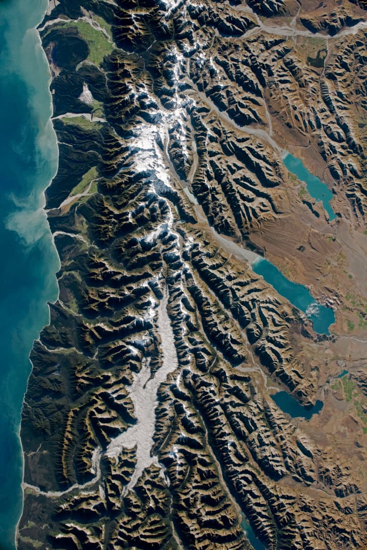
New Zealand's Southern Alps: oblique plate collision, rapid uplift, glacial carving, and sediment-loaded rivers.
NASA Earth Observatory; ISS Crew Earth Observations Facility and Earth Science and Remote Sensing Unit, Johnson Space Center. · NASA media use guidelines · source
New Zealand is one of the very few places on Earth where an active plate boundary runs across dry land as a single, visible feature. The Alpine Fault slices 600 km up the spine of the South Island, marking where the Pacific and Australian plates grind past and into each other. GNS Science measures the total relative plate motion at roughly 37–40 mm per year, most of it taken up by the fault itself, which has slipped horizontally about 30 metres every 1,000 years — 'very fast by global standards' in GNS's own words. Stand at the foot of the Western Alps escarpment near Franz Josef and you are standing at the seam between two tectonic plates.
The Southern Alps are the crumpled edge of that collision. Because the plates converge obliquely, rock on the Pacific side is not just dragged sideways but driven upward: over the last 12 million years the Southern Alps have been uplifted by an astonishing ~20 km — yet ferocious erosion by rain, ice and rivers has kept Aoraki/Mount Cook below 4,000 m (it stands at 3,724 m). Modern GNSS surveys resolve ongoing bedrock uplift of about 5 mm per year across the central Southern Alps, and thermochronology shows rocks near Aoraki being exhumed at 8 ± 3 mm per year — among the fastest rates measured anywhere on Earth. The summits themselves are made of greywacke sandstone and schist: former seafloor sediments, cooked and squeezed, now standing 3 km above the ocean that deposited them.
The fault keeps score in earthquakes. Paleoseismic records compiled by GNS Science show the Alpine Fault ruptures in a great earthquake roughly every three centuries; the last was in 1717, and GNS-led research published in 2021 estimated a ~75% probability of a large Alpine Fault earthquake within the next 50 years. This is not an abstraction for trekkers — it is why huts, road crossings and civil-defence planning on the West Coast are built around the 'AF8' scenario.
The North Island tells the other half of the plate-boundary story. Here the Pacific Plate dives beneath the Australian Plate at the Hikurangi subduction margin, and the melt rising off that sinking slab feeds the Taupō Volcanic Zone. Tongariro and Ruapehu — the volcanoes of the Tongariro Alpine Crossing and New Zealand's oldest national park — are andesitic stratovolcanoes at the zone's southern end. Both are alive on human timescales: Tongariro's Te Maari craters erupted in August and November 2012, and Ruapehu last erupted in September 2007 after its damaging 1995–96 episode. The GeoNet programme — run by Earth Sciences New Zealand (formerly GNS Science) — monitors both around the clock; as of August 2026 Ruapehu sits at Volcanic Alert Level 1 (minor volcanic unrest) and Tongariro at Level 0 (no volcanic unrest). Check GeoNet before you walk the Crossing — the mountain you cross is officially, and visibly, still in business.
What you can see on the trail
Red Crater — a steaming, oxidized volcanic vent with an exposed lava dike
📍 High point of the Tongariro Alpine Crossing (~1,868 m), between South Crater and the Emerald Lakes descent
The rusty red is iron in the scoria oxidized by volcanic heat and gases, and the hollow black rib in the crater wall is a drained lava dike — a feeder pipe of the volcano cut open for you. The ground is still hot: this vent last erupted in the 1920s and steams today.
📍 Directly below Red Crater on the Tongariro Alpine Crossing descent toward Central Crater
The unreal blue-green comes from dissolved minerals and sulfur washed in from geothermal seeps around old explosion craters. The smell of sulfur on the wind is the volcano's plumbing, still connected below your boots.
Aoraki's rising greywacke wall and fresh glacial moraines
📍 Hooker Valley Track, Aoraki/Mount Cook National Park — from the swing bridges and Hooker Lake terminus
Every peak around you is former seafloor sandstone (greywacke) driven upward by the plate collision — rocks here rise at several millimetres a year, among the fastest measured on Earth. The grey moraine walls flanking the track are rubble bulldozed by glaciers that have retreated dramatically within living memory.
The Alpine Fault itself — the Pacific–Australian plate boundary in outcrop
📍 Gaunt Creek near Whataroa (guided access, close to the Franz Josef corridor); the abrupt mountain front along SH6 traces the fault for kilometres
At Gaunt Creek the fault plane is exposed at the surface: pale, crushed fault rock (mylonite and gouge) thrust over young river gravels. It is one of the very few places on Earth where you can put your hand on an active plate boundary.
Fun fact
In the last 12 million years the Southern Alps have been uplifted about 20 kilometres — but erosion has stripped almost all of it away, keeping Aoraki below 4,000 m. An entire mountain range's worth of rock has been shed into the Tasman Sea.