Sunda Arc subduction volcanismarc volcanism active through the Quaternary; Rinjani complex Quaternary; Samalas caldera collapse 1257 CEAustralian Plate subducting beneath the Sunda Plate at the Java Trench (~7 cm/yr; 7.0–7.3 cm/yr near Lombok per MORVEL, DeMets et al. 2010)🌋 stratovolcano complex with a collapse caldera (Samalas / Segara Anak) and an active post-caldera cone (Barujari) — PVMBG (via the official MAGMA Indonesia platform): Level II — Waspada as of August 2026, with a 1.5-km exclusion radius around the active Barujari crater. Rinjani is an active volcano; check MAGMA Indonesia before trekking.
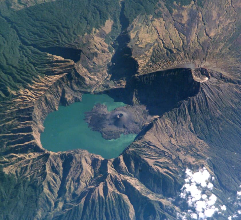
Rinjani's Segara Anak caldera: the missing mountain is the geology, with a younger cone growing inside the lake.
NASA International Space Station image ISS005-E-15296, via Smithsonian GVP. · Public Domain Work · source
Lombok sits on the Sunda Arc, one of the most productive volcanic lines on Earth. Offshore to the south, at the Java Trench, the Australian Plate dives beneath the Sunda Plate at about 7 cm per year (7.0–7.3 cm/yr near Lombok in the MORVEL global model). Water carried down with the slab lowers the melting point of the overlying mantle, and the magma that results rises to feed the chain of volcanoes running the length of the archipelago — an arc so active that Indonesia's geological agency, PVMBG, keeps dozens of volcanoes under close observation through its MAGMA Indonesia monitoring platform.
The Rinjani massif hides the arc's most extraordinary story. For decades, ice cores from both Greenland and Antarctica recorded a colossal sulfate spike at 1257–1258 CE — the fingerprint of a giant eruption nobody could place. In 2013, Lavigne and colleagues (PNAS) solved the mystery: the source was Samalas, a volcano that once stood beside Rinjani on Lombok. Matching geochemistry, radiocarbon dates and the Old Javanese chronicle Babad Lombok, they reconstructed an eruption that expelled at least 40 km³ of magma (dense-rock equivalent), drove an ash column up to 43 km high, and sent pyroclastic flows all the way to the coast, 25 km away — burying Pamatan, capital of a Lombok kingdom, which the chronicle says was destroyed with many of its people.
The planet felt it. The 1257 Samalas event was the largest stratospheric volcanic gas release of the Common Era (Vidal et al. 2016, Scientific Reports), and proxy records show it triggered some of the coldest summers of the past millennium in parts of the Northern Hemisphere (Guillet et al. 2017, Nature Geoscience). Medieval European chronicles describe a dismal 1258; the eruption has even been linked — cautiously, by historians — to famine burials in London. It ranks among the largest Holocene explosive eruptions anywhere on Earth, with a magnitude of 7 (VEI 7).
Today the trek walks straight through the aftermath. Where Samalas stood is now a vast caldera holding the crescent lake Segara Anak at about 2,000 m elevation, with hot springs seeping through its shores and the young cone Gunung Barujari — born after the collapse — rising from the water. Barujari is very much alive: it last erupted on 27 September 2016, and as of August 2026 PVMBG keeps Rinjani at Level II (Waspada) on its four-level scale, with a 1.5-km exclusion radius around the active Barujari crater. Rinjani's geological heritage was recognized in 2018, when it became the Rinjani-Lombok UNESCO Global Geopark — always check MAGMA Indonesia before any summit or crater-rim trek.
What you can see on the trail
Segara Anak caldera — the hole the 1257 eruption left behind
📍 Plawangan Sembalun crater rim (~2,639 m), first summit-night vantage on the Sembalun route; also Plawangan Senaru rim
The enormous bowl below the rim, holding a lake at ~2,000 m, is what remains after Samalas expelled at least 40 km³ of magma in 1257 and collapsed into its emptied chamber. You are camped on the rim of one of the biggest eruptions of the last 7,000 years.
Gunung Barujari — the living cone inside the lake
📍 From the crater rim camps and the lakeshore section of the Senaru–Sembalun traverse
This dark cone growing out of Segara Anak is the volcano rebuilding itself after the 1257 collapse. It last erupted in 2016, which is why PVMBG holds Rinjani at alert Level II with a 1.5-km no-go radius around the crater.
1257 pumice underfoot on the Sembalun grasslands
📍 Sembalun route, the long savanna approach below Plawangan Sembalun
The pale, feather-light stones scattered along the trail are trachydacite pumice from the Samalas eruption — pyroclastic material that mantled the whole region 769 years ago. Pick one up: it floats.
Aik Kalak hot springs by the lake
📍 Lakeshore camp on the Senaru–Sembalun traverse, below the rim
Hot water seeping into pools beside Segara Anak is direct evidence of the magmatic heat still stored beneath the caldera — the same hydrothermal system that feeds Barujari.
Fun fact
The 1257 eruption was traced by matching volcanic glass tied to the largest bipolar ice-core sulfate spike of the last 7,000 years — in both Greenland and Antarctica — to Lombok's pumice: a planetary detective case closed 756 years later, in 2013.
Rocks: trachydacite pumice (1257 Samalas fall deposits) · andesite and basaltic-andesite lavas (Rinjani edifice and Barujari cone) · ignimbrite and pyroclastic-flow deposits (reaching the coast 25 km away) · hydrothermally altered rock and hot-spring deposits (Segara Anak shores)