
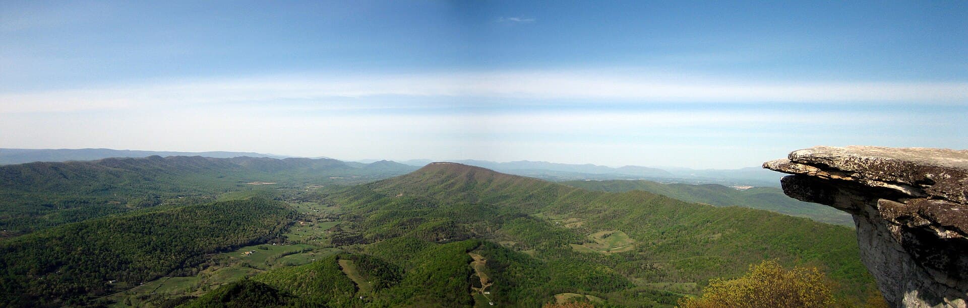
Two crowns without the crowd
The maintaining club's own definition is tidy: "Virginia's Triple Crown — Dragon's Tooth, McAfee Knob and Tinker Cliffs — is part of the Appalachian Trail between VA 620 (Trout Creek) and VA 652" (RATC — McAfee Knob and Virginia's Triple Crown). One ridge system, three landmarks — and one of them absorbs nearly all the attention. McAfee Knob receives about 60,000 visitors a year by RATC's count, making it one of the busiest single points on the entire trail.
The premise of this article is the other two thirds. You do not need three days, a backpack, or a shelter reservation that doesn't exist anyway to collect Dragon's Tooth and Tinker Cliffs. Each is an honest, self-contained day hike — and by most technical measures, each is a better hike than the famous one.
| Dragon's Tooth | Tinker Cliffs (via Andy Layne) | |
|---|---|---|
| Round trip | 4.8 mi | 7.6-8.1 mi |
| Gain | ~1,300 ft | ~1,900-2,000 ft |
| Rating | strenuous | strenuous |
| Signature | iron-rung scramble to a 35-ft Tuscarora quartzite spire | half-mile cliff-edge walk, 180° views back to McAfee Knob |
| Trailhead | Dragon's Tooth trailhead — a stop on the $6 shuttle | VA 779 — not on the shuttle |
| The catch | rock is treacherous wet — fair-weather only | private-land approach; no camping anywhere on the route |
Sources: Go Hike Virginia — Dragon's Tooth; Go Hike Virginia — Tinker Cliffs; Visit Virginia's Blue Ridge — Tinker Cliffs; Roanoke County — McAfee Knob Trailhead Shuttle.
Dragon's Tooth: the hands-on day
On paper, Dragon's Tooth is the short one: 4.8 miles round trip, about 1,300 ft of gain. The strenuous rating lives entirely in how those numbers end. The final Appalachian Trail section to the ridge climbs on iron rungs set into the rock face and, in Go Hike Virginia's exact phrasing, demands "full access to hands, feet, elbows, toes, fingers and knees." The payoff is the Tooth itself — a 35-ft spire of Tuscarora quartzite on Cove Mountain (about 2,889 ft) that you can scramble to an airy perch atop (Go Hike Virginia — Dragon's Tooth).
Calibrate that honestly. This is the closest thing the region has to a Colorado Class 3 route: rungs, hands-on rock, real attention required — with roughly a tenth of the fall consequence of a Rockies scramble. What gatekeeps Dragon's Tooth is not rope skills. It is weather and footwear. The quartzite is treacherous when wet, and the route is fair-weather terrain, full stop. If the forecast is rain, this is the day you swap, not the day you push — the rungs will still be bolted to the mountain next weekend.
One more constraint that surprises people at 2,900 ft: there is nothing to drink up there. RATC's warning is written for campers but applies verbatim to a July day hiker: "There are no natural water sources along the A.T. in the Dragons Tooth area, so bring all your water" (RATC). Carry the full day's supply from the car.
Continue reading The Virginia Triple Crown in three days: seven legal campsites, zero permits →
Tinker Cliffs: cows, stone steps, and the quiet crown
Tinker Cliffs is the crown almost nobody day-hikes, and the approach explains why the ones who do come back evangelical. From the VA 779 trailhead, the blue-blazed Andy Layne Trail runs 3.0 miles up through pastureland donated by Roanoke Cement — two creek footbridges, more than 100 built steps, and actual cows — to Scorched Earth Gap on the Appalachian Trail. Turn south, and the A.T. delivers you onto a half-mile line of Tuscarora quartzite cliffs that the trail walks right along the edge of, with 180-degree views back across the valley to McAfee Knob. The full day: 7.6-8.1 miles round trip, roughly 1,900-2,000 ft of gain (Go Hike Virginia — Tinker Cliffs; Visit Virginia's Blue Ridge — Tinker Cliffs).
Two rules define this hike, and both trace to the same fact: the Andy Layne Trail crosses private property. The access is a goodwill arrangement, not a right — which is why camping is banned along the entire approach. And the cliffs themselves are no refuge from that rule. The official ATC/NPS restriction map is unambiguous: along 28 miles of the A.T. through this corridor, camping is only permitted at 7 designated sites, and Tinker Cliffs — like McAfee Knob — is marked NO CAMPING, with fires legal only in the metal rings at designated sites (ATC/NPS camping-restriction map; Visit Virginia's Blue Ridge — Triple Crown).
The practical translation for a day hiker: a sunset from the cliff line means a headlamp descent through the pastures, planned in advance. If you want to sleep out here instead, the map's seven names — from John's Spring Shelter to Lamberts Meadow Campsite — are the entire legal universe, and that turns your day hike into the loop covered in its own article.
One shuttle, two trailheads — and the crown it doesn't reach
The Triple Crown's only real bottleneck is parking, and the fix is a bus. The McAfee Knob Trailhead Shuttle serves both the McAfee Knob and Dragon's Tooth trailheads, which makes a car-free scramble day genuinely possible — something almost no US trail region can claim.
| Item | 2026 |
|---|---|
| Season | 6 Mar - 29 Nov 2026, Fri/Sat/Sun + holiday Mondays |
| Fare | $6 one-way / $11 round trip + fees; 20 seats per run |
| Stops | I-81 Exit 140 Park & Ride, Orange Market (311), downtown Salem (101 S Broad), Longwood Park, Dragon's Tooth trailhead, McAfee Knob trailhead |
| Hours | 7 a.m.-7 p.m. Apr-Sep; shorter in shoulder months |
| Roadside parking on Route 311 | banned — ticketed and towed |
Sources: Roanoke County — McAfee Knob Trailhead Shuttle; booking at McAfeeShuttle.com; route & schedule.
Note what the table does not contain: the Andy Layne trailhead on VA 779. Tinker Cliffs is the crown the shuttle doesn't serve — the quiet one asks for a car, which is a fair trade for having the cliff line nearly to yourself.
And note what neither day costs: anything else. There is no entry fee, no camping fee, and no permit at any scale in this region — the ATC's own page confirms most of the Appalachian Trail requires neither, and the Triple Crown loop guide states flatly "Permits: Not Required" (ATC — Permits & fees; Into the Backcountry — Triple Crown loop guide). A weekend of both crowns runs $11 of bus fare plus gas.
Honest grading where there is no altitude
Here is the difficulty math this region actually runs on, because it is not the math US hikers are trained for.
What these hikes lack: altitude, entirely. Cove Mountain is about 2,889 ft; McAfee's surveyed summit is 3,197 ft (Go Hike Virginia — McAfee Knob; Wikipedia — McAfee Knob). Nothing here approaches the elevations where acclimatization becomes a variable. Full oxygen, all day, every day.
What they have instead: three constraints that do the gatekeeping altitude does elsewhere.
- Wet quartzite. Dragon's Tooth's rungs and slabs are fair-weather terrain; rain converts a strenuous hike into an accident report. The rock, not the grade, sets the go/no-go.
- Dry ridgelines. No natural water in the Dragon's Tooth area, and the full loop crosses a roughly 12-mile waterless stretch — "water is scarce on this particular hike" is the loop guide's blunt summary (Into the Backcountry; RATC). At 3,000 ft in mid-Atlantic summer heat and humidity, carrying capacity matters more than it does on many 12,000-ft trails.
- The calendar. The thru-hiker wave is real: ATC's registers logged 2,187 northbound starts in 2025 (ATC — 2,000-milers), clustered from early March to early April (The Trek — 2025 thru-hiker survey) — which puts the bubble over the Triple Crown roughly late May through June. For the quietest cliffs, hike off-wave weekdays, or wait for September-October.
The Colorado playbook — start at dawn, carry capacity, respect rock in the rain — transfers to Virginia intact. The reasons don't. Both "strenuous" ratings here are earned by terrain and water, not thin air, and treating them as beginner hikes because the summits are low is exactly the mistake the grading exists to prevent.
From à la carte to the tasting menu
The quiet argument for doing these as day hikes first: they are the loop's reconnaissance. The full Virginia Triple Crown circuit runs 35 miles in the destination-official 3-day version, or 38.5 miles with 6,874 ft of gain in the most detailed verified guide — which builds the loop from the A.T. plus three connectors: the Andy Layne Trail, the North Mountain Trail, and the Dragon's Tooth Trail (Visit Virginia's Blue Ridge — Triple Crown; Into the Backcountry). Two of those three connectors are the very approaches described above. Hike both days and you have already walked the loop's entry ramps, met its scramble, and learned its water problem — with a car (or a bus) waiting at the bottom instead of a dry camp.
When you do commit to the full circuit, the rules scale up with the miles: camping at the 7 designated sites only, and — since the National Park Service's June 2026 notice — mandatory overnight storage of food, trash, and scented items in bear boxes, an IGBC-approved canister, or a proper hang, 12 ft up and 6 ft out (ATC — McAfee Knob area bear activity). The full shelter-by-shelter plan lives in the loop article.
One last argument for the à-la-carte version, and it is served family-style: Catawba — the valley community between Dragon's Tooth and McAfee — got its legendary table back when The Homeplace Restaurant reopened on 22 April 2026 after five years closed, Wed-Fri 4-8 p.m. and weekends 11 a.m.-8 p.m. (WDBJ7). Backpackers smell that farmhouse for three days. A day hiker just drives to it.
The Triple Crown checks no tickets and counts no summits. Take it one crown at a time — the ridge keeps no score.
16 Sources
- ratc.orgRATC — McAfee Knob and Virginia's Triple Crown — Triple Crown definition, ~60,000 visitors, no water in the Dragon's Tooth area, metal-ring fire rule
- gohikevirginia.comGo Hike Virginia — Dragon's Tooth — 4.8 mi, ~1,300 ft, iron rungs, 35-ft Tuscarora spire, Cove Mountain, wet-rock warning
- gohikevirginia.comGo Hike Virginia — Tinker Cliffs — 8.1 mi / 1,995 ft, Andy Layne detail: footbridges, steps, pasture
- gohikevirginia.comGo Hike Virginia — McAfee Knob — McAfee route and elevation figures
- en.wikipedia.orgWikipedia — McAfee Knob — 3,197-ft surveyed summit
- visitroanokeva.comVisit Virginia's Blue Ridge — Tinker Cliffs — 7.6 mi / 1,900+ ft, Tuscarora quartzite, 180° views
- visitroanokeva.comVisit Virginia's Blue Ridge — Virginia's Triple Crown — 35-mile 3-day loop, camping prohibited on McAfee Knob and Tinker Cliffs
- roanokecountyva.govRoanoke County — McAfee Knob Trailhead Shuttle — 2026 season, $6/$11 fare, stops, hours, Route 311 towing
- mcafeeshuttle.comMcAfeeShuttle.com — shuttle booking
- mcafeeshuttle.comMcAfeeShuttle.com — route & schedule — stop list including Dragon's Tooth
- ratc.orgATC/NPS camping-restriction map (RATC-hosted PDF) — 28 miles / 7 designated sites, NO CAMPING at the cliffs, Andy Layne private land
- appalachiantrail.orgATC — Permits & fees — no permits or fees on most of the A.T.
- intothebackcountryguides.comInto the Backcountry — Virginia's Triple Crown Loop backpacking guide — 38.5 mi / 6,874 ft, three connectors, "Permits: Not Required," water scarcity, ~12-mile dry stretch
- appalachiantrail.orgATC — McAfee Knob area: ongoing bear activity — June 2026 mandatory food-storage requirement
- appalachiantrail.orgATC — 2,000-milers — 2,187 northbound starts in 2025
- thetrek.coThe Trek — 2025 A.T. thru-hiker survey, part 1 — start dates clustered early March-early April