
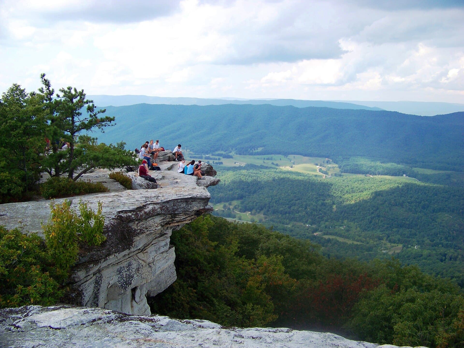
The ledge that talked its way onto the trail
McAfee Knob is on the Appalachian Trail because a hiking club argued it there. Myron Avery's original plan for the A.T. through this part of Virginia ran along the Blue Ridge crest roughly 15 miles (24 km) to the east — and the ledge that would become the trail's signature photograph was not on it.
The counterargument came from a club that was weeks old. On November 13, 1932, three local groups — the Roanoke College outings club, the Hollins College outings club, and The Nomads, a hiking club largely made up of Roanoke and Salem women — merged after a Carvins Cove hike and supper into the Roanoke Appalachian Trail Club: 17 founding members, and roughly 70 miles (113 km) of new route blazed within a year. In 1933 the new club talked Avery into swinging the trail west through the Catawba Valley ridges — "there are few points of outstanding interest on the southern route" — putting Tinker Mountain and the McAfee country on the A.T. for good. Sources: ATC — How hikers helped route the A.T. to McAfee Knob; RATC — How three hiking clubs became the RATC.
Ninety-three years later, RATC volunteers still maintain 120+ miles (193+ km) of the A.T. and its side trails through the region (RATC). Be precise about the fame, because the precision is the story: the ATC's own article calls the Knob "one of the most photographed spots on the Appalachian Trail," and regional tourism rounds that up to the most photographed (ATC; Visit Virginia's Blue Ridge). Either way, the most famous view on the trail exists as a destination because local hikers put it there — and local volunteers have been absorbing the consequences ever since.
What the hike actually is
| Fact | Value |
|---|---|
| The ledge | 3,130 ft (954 m) ledge line; summit surveyed at 3,197 ft (974 m) |
| Round trip | ~8.0 mi (12.9 km) from the VA 311 trailhead |
| Elevation gain | ~1,650 ft (503 m) |
| Typical time | 4-6 hours |
| Permit | none — no fee, no quota, no reservation |
| Annual visitors | ~50,000-60,000 |
Sources: Go Hike Virginia — McAfee Knob (8.0 mi, 1,654 ft, 3,130 ft, times); Wikipedia — McAfee Knob (3,197 ft); RATC — the Triple Crown ("just under 8 miles round-trip," ~60,000 visitors); WDBJ7 (~50,000); ATC — permits & fees.
Two routes leave the same trailhead, and the smart day uses both. The white-blazed A.T. is the scenic line, passing two of the corridor's shelters on the way up; the blue-blazed old fire road is 2.2 miles (3.5 km) of easy grade. Most hikers loop them — A.T. up, fire road down (Go Hike Virginia).
One thing you no longer do: sprint across Route 311. Since March 27, 2025, the A.T. crosses the highway on a 90-ft (27 m), 8-ft-wide (2.4 m) steel-and-concrete pedestrian bridge, 17.5 ft (5.3 m) above the roadway — a $1.5M VDOT contract built by Stonewall Bridge Inc. of Vinton and maintained by the National Park Service, ending decades of hikers dashing a blind curve. Sources: VDOT; ATC.
Continue reading White blazes and shelter registers: how the Appalachian Trail actually works →
Fifty thousand people, zero permits
Here is what makes McAfee Knob nationally interesting beyond the photograph. It is one of the busiest single points on the entire 2,190-mile (3,524 km) trail, and the management response has never been rationing. No timed entry, no lottery, no quota — no permit has been imposed or, in any verified source, formally proposed. While the marquee Western parks were building reservation systems, this corridor built infrastructure and staffed it with volunteers: the bridge, a $6 shuttle, and the McAfee Knob Task Force — RATC's ridgerunner corps, founded in 2014. The Task Force's ten-year tally: 137,000 day hikers, 21,000 backpackers and 5,500 thru-hikers observed. In 2024 alone: 287 patrols, roughly 15,000 visitors counted and 13,500+ engaged in conversation, 67 illegal fire rings dismantled, 238 gallons (901 L) of trash carried out. Sources: RATC — McAfee Knob Task Force; ATC — permits & fees.
That model — education plus infrastructure instead of gates — only keeps working if visitors hold up their side. The two rules that follow, parking and camping, are the whole bargain.
Parking is the crux — and there is a bus
The bottleneck at McAfee Knob is not money or permits. It is asphalt, or the lack of it.
- The trailhead lot on VA 311 is free — and only ~50 gravel spaces. It fills early on any fair-weather weekend (WDBJ7).
- Roadside parking on Route 311 is banned — ticketed and towed, not theoretically but as routine enforcement (Roanoke County).
- Relief is funded: $6.3 million in federal money, announced February 26, 2026, will rebuild the lot into 100+ striped spaces with ADA parking, waterless restrooms, better signage and a permanent shuttle stop (WDBJ7). Expect construction disruption — check status before a 2026-27 visit.
The adult answer, and the one to treat as the default rather than the fallback, is the shuttle: $6 one-way, $11 round trip (plus booking fees), 20 seats per run, running March 6 through November 29, 2026, Fridays through Sundays plus Memorial Day and Labor Day Mondays, 7 a.m.-7 p.m. April-September with shorter shoulder-season hours. Stops: the I-81 Exit 140 Park & Ride, Orange Market on 311, downtown Salem (101 S Broad), Longwood Park, the Dragon's Tooth trailhead and the McAfee trailhead — meaning the shuttle also unlocks a car-free Triple Crown weekend. Sources: Roanoke County — McAfee Knob Trailhead Shuttle; booking at McAfeeShuttle.com.
Go one step further and the whole trip is car-free: Amtrak's Northeast Regional runs two daily round trips into downtown Roanoke, about 5 hours from Washington Union Station (Visit VBR — Amtrak). Train, shuttle, ledge. Few American trailheads can say that.
The legal sunrise plan
Now the rule that gets broken more than any other in this region, and the one this article exists to fix.
Camping and fires are banned on McAfee Knob itself. Along 28 miles (45 km) of the A.T. through this corridor, camping is legal at exactly seven designated sites — John's Spring Shelter, Catawba Mountain Campsite, Catawba Mountain Shelter, Campbell Shelter, Pig Farm Campsite, Lamberts Meadow Shelter and Lamberts Meadow Campsite — and at none of the ground between them. The trail here runs a narrow National Park Service-owned corridor, and the restriction exists to concentrate impact. McAfee Knob and Tinker Cliffs are both explicitly marked NO CAMPING; fires are allowed only in the metal rings at designated sites. Sources: ATC/NPS camping-restriction map (PDF); RATC; Visit VBR — Triple Crown.
So the sunrise photograph — the one every feed shows shot from a tent on the ledge — is either illegal or planned like this:
- Walk in the afternoon before. Take the A.T. up, over the Knob, and continue 0.7 mile (1.1 km) beyond the summit to Pig Farm Campsite or Campbell Shelter — the two legal overnights closest to the ledge. First-come, free, like every shelter on the A.T. (ATC — camping & shelters).
- Store food like it is the law, because since June 2026 it is. After a mother bear and cubs took hikers' food at Catawba Mountain Shelter, the NPS now requires overnight hikers in the Triple Crown area to secure food, trash and all scented items — provided bear boxes, cables or poles, an IGBC-approved canister, or a proper hang 12 ft (3.7 m) up and 6 ft (1.8 m) out. Campbell Shelter and Pig Farm are both named frequent-activity sites, and the ATC strongly recommends carrying a canister (ATC — ongoing bear activity).
- Walk back up by headlamp. The pre-dawn 0.7 mile is the price of the legal shot. Coffee on the ledge, first light over the Catawba Valley, no ranger conversation, no flattened vegetation on the most photographed ground on the trail.
That is the entire trick. It costs one short dark walk and $0.
Timing the tide: you versus the NOBO wave
The Knob's crowds run on two clocks. The first is obvious: fair-weather weekends, which the shuttle exists to absorb. The second is the thru-hiker wave, and it is predictable to the week.
ATC registers logged 2,187 northbound thru-hike starts in 2025, clustered from early March to early April (ATC — 2,000-milers; The Trek — 2025 survey). By mid-May the bubble is at Trail Days in Damascus — May 15-17 in 2026, swelling the town to some 25,000 people (ATC — Trail Days 2026; Visit Damascus). Damascus sits near northbound mile 476-486; Catawba Mountain Shelter is northbound mile 713.3 (ATC). Run that arithmetic forward and the wave rolls over McAfee Knob roughly late May through June — exactly when the seven legal campsites fill.
So: day hikers who want the ledge quiet should aim for weekdays outside that window, or for September-October, when the wave is long gone, the humidity breaks and the shuttle still runs until November 29. Sunrise campers in the May-June window need bear-storage discipline and a plan B campsite.
One last piece of timing luck: the classic finish is back. The Homeplace Restaurant in Catawba — the family-style, all-you-can-eat farmhouse that generations of thru-hikers rated the best meal on the trail — reopened April 22, 2026 after five years dark, serving Wednesday-Friday 4-8 p.m. and weekends 11 a.m.-8 p.m. (WDBJ7). Ledge at sunrise, farmhouse by noon. Done right, McAfee Knob is not a photo stop. It is the best-managed busy summit in American hiking — and the management is you, parking where the county asks, sleeping where the map says, and hanging your food where the bears cannot reach it.
24 Sources
- appalachiantrail.orgATC — How hikers helped route the A.T. to McAfee Knob — 1933 reroute, Avery's crest plan, "one of the most photographed spots"
- ratc.orgRATC — How three hiking clubs became the RATC — November 13, 1932 founding, 17 members, ~70 miles blazed
- ratc.orgRATC — home — 120+ miles maintained today
- ratc.orgRATC — McAfee Knob and Virginia's Triple Crown — ~60,000 visitors, route length, fire-ring rule
- ratc.orgRATC — McAfee Knob Task Force — ridgerunner corps since 2014, patrol and trash statistics
- gohikevirginia.comGo Hike Virginia — McAfee Knob — 8.0 mi, 1,654 ft gain, 3,130-ft ledge, both routes, 4-6 hours
- en.wikipedia.orgWikipedia — McAfee Knob — 3,197-ft surveyed summit
- visitroanokeva.comVisit Virginia's Blue Ridge — McAfee Knob — "most photographed" framing
- wdbj7.comWDBJ7 — $6.3 million to upgrade McAfee Knob trailhead — February 26, 2026 award, ~50 spaces, 100+ planned, ~50,000 visitors
- roanokecountyva.govRoanoke County — McAfee Knob Trailhead Shuttle — 2026 season, $6/$11 fare, stops, towing enforcement
- mcafeeshuttle.comMcAfeeShuttle.com — shuttle booking
- vdot.virginia.govVDOT — new A.T. pedestrian bridge over Route 311 opens — bridge specs, $1.5M contract, March 27, 2025
- appalachiantrail.orgATC — McAfee Knob trailhead pedestrian bridge now open — bridge opening
- ratc.orgATC/NPS Triple Crown camping-restriction map (PDF) — 28 miles, 7 designated sites, NO CAMPING zones
- visitroanokeva.comVisit Virginia's Blue Ridge — Virginia's Triple Crown — camping prohibited on McAfee Knob and Tinker Cliffs
- appalachiantrail.orgATC — McAfee Knob area: ongoing bear activity — June 2026 NPS food-storage requirement, mile 713.3
- appalachiantrail.orgATC — permits & fees — most of the A.T. requires no permit or fee
- appalachiantrail.orgATC — camping & shelters — free first-come shelters, camping doctrine
- appalachiantrail.orgATC — 2,000-milers — 2,187 northbound starts in 2025
- thetrek.coThe Trek — 2025 A.T. thru-hiker survey, part 1 — start dates cluster early March-early April
- appalachiantrail.orgATC — Trail Days 2026 — May 15-17, 2026
- visitdamascus.orgVisit Damascus — Trail Days — ~25,000 attendees
- visitroanokeva.comVisit Virginia's Blue Ridge — Amtrak — two daily round trips, ~5 hours from Washington
- wdbj7.comWDBJ7 — Catawba's Homeplace Restaurant back open — April 22, 2026 reopening, hours