A conveyor belt of islands over a mantle blowtorch
Hawaiian hotspot volcanism (Hawaiian–Emperor chain)~5.1 Ma (Kauaʻi shield, K–Ar) to present (Kīlauea erupting; Kamaʻehuakanaloa still submarine)Pacific Plate moving NW (~8.5 cm/yr, USGS-published rate relative to the hotspot) over the near-stationary Hawaiian mantle plume🌋 hotspot shield volcanoes (Kīlauea, Mauna Loa active; Mauna Kea post-shield; Kamaʻehuakanaloa submarine) — USGS Hawaiian Volcano Observatory: Kīlauea and Mauna Loa are ACTIVE (Kīlauea in episodic eruption since Dec 2024); Mauna Kea is dormant/quiescent — USGS states it last erupted ~4,600 years ago (some USGS pages say ~4,500) and 'will erupt again'. HVO monitors six volcanoes including Hualālai and Haleakalā.
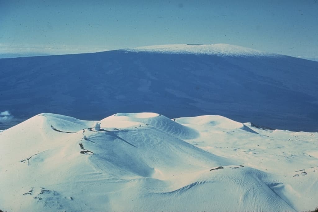
Mauna Loa and Mauna Kea show the hotspot signature: wide basaltic shields rather than steep cones.
Photo by Don Swanson, U.S. Geological Survey, via Smithsonian GVP. · Public Domain Work · source
Most of the world's great volcano chains sit on the edges of tectonic plates. Hawaiʻi breaks the rule: it rises from the middle of the Pacific Plate, thousands of kilometres from the nearest boundary. The engine underneath is a hotspot — a plume of anomalously hot mantle rock whose partial melting feeds basaltic magma to the surface (USGS). Because that lava is hot, fluid basalt rather than the sticky andesite of subduction arcs, it spreads out into broad, gently sloped shield volcanoes: mountains built from tens of thousands of thin flows stacked one on top of another.
The hotspot stays roughly fixed while the Pacific Plate slides northwest over it — the USGS-published rate relative to the hotspot is about 8.5 cm per year. Each volcano is eventually carried off its magma supply, falls quiet, erodes and subsides, while a new one is born to the southeast. The result is the 5,800-km Hawaiian–Emperor chain of islands and drowned seamounts. Read the islands from northwest to southeast and you read time itself: Kauaʻi's shield lavas are about 5.1 million years old (K–Ar, USGS), the Big Island's are younger than half a million years and still accumulating, and offshore to the southeast the submarine volcano Kamaʻehuakanaloa (formerly Lōʻihi) is already building the next stop on the line.
Mauna Kea is where the famous superlative lives — and it survives careful checking, with one honest caveat. Its summit stands 4,207 m above sea level, but the USGS notes its flanks continue roughly 6,000 m down to the deep seafloor, for a base-to-summit height of about 10,211 m — more than a kilometre taller than Everest's 8,849-m elevation. Everest remains the highest point above sea level; Mauna Kea is the tallest mountain measured from its base, with the caveat that the submarine 'base' of a gentle shield is a line scientists must draw somewhat by convention. Mauna Kea is in its post-shield stage, capped with cinder cones of alkalic lava — and during Pleistocene ice ages its summit carried glaciers, whose moraines still ring the top of a tropical Pacific island (USGS Hawaiian Volcano Observatory).
The hotspot's present output is impossible to miss. Kīlauea, one of the most active volcanoes on Earth, has been erupting episodically from Halemaʻumaʻu crater since 23 December 2024 — episode 53 of the sequence sent lava fountains about 150 m (500 ft) high over 12–13 August 2026 (USGS HVO). Mauna Loa, the planet's largest active volcano, last erupted in November–December 2022. Mauna Kea, by contrast, is officially dormant: the USGS states it last erupted about 4,600 years ago — and that it will erupt again someday.
What you can see on the trail
Solidified 1959 lava lake — a crusted, still-steaming crater floor
📍 Kīlauea Iki Trail, Hawaiʻi Volcanoes National Park (crossing the crater floor)
In 1959 this crater held a lake of molten lava fed by 17 fountain episodes — one fountain reached 580 m, the highest ever measured at Kīlauea (USGS). You walk across its crusted surface, past cracks that still vent steam.
Halemaʻumaʻu crater — vents of the ongoing episodic eruption
📍 Crater Rim Trail overlooks (Uēkahuna and Keanakākoʻi), Hawaiʻi Volcanoes National Park
The summit crater of Kīlauea has erupted in dozens of discrete lava-fountaining episodes since December 2024. When an episode is running, the glow and fountains are visible from the rim overlooks; check USGS HVO updates.
Puʻupuaʻi cinder cone and the tephra desert it buried
📍 Devastation Trail, Hawaiʻi Volcanoes National Park
The 1959 fountains rained cinder downwind, building the Puʻupuaʻi cone and burying a rainforest in tephra. The trail crosses the half-recovered devastation zone — fountain deposits you can read like a fresh snowfall.
Ice-age moraines and Lake Waiau near the summit of Mauna Kea
📍 Humuʻula Trail to the Mauna Kea summit plateau
Glacial deposits at ~4,000 m on a tropical Pacific island: Pleistocene ice caps left moraines and the small basin holding Lake Waiau, one of the highest lakes in the USA (USGS HVO).
Fun fact
Measured from its base on the seafloor, Mauna Kea stands about 10,211 m (USGS) — over a kilometre 'taller' than Everest's 8,849 m — and its summit carried glaciers during the last ice age.
Rocks: tholeiitic basalt (shield-stage pāhoehoe and ʻaʻā flows) · alkalic basalt and hawaiite (Mauna Kea post-shield cap) · cinder, tephra and reticulite (lava-fountain deposits) · olivine-rich picritic basalt